
Sharrows help promote safer cycling
The June edition of Whitehorse News has an article about Sharrows which have started to appear on several local streets in Whitehorse. 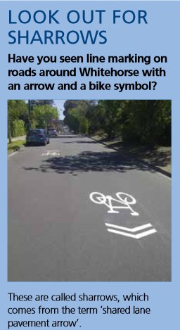 Click here to link to tthe article which is on page 3.
Sharrows are new in Whitehorse but anyone traveling about in City of Yarra and other inner municipalites will be very familiar with them.
Sharrows are principally used to let everyone know – particularly cars – that this section of road is a shared space, and that cars have no greater right to the roadway than cyclists.
* They are also a guide to cyclists to indicate where the safest path my be such as “claiming the lane” within a roundabout which means riding in the centre where the sharrow is rather then keeping left.
* Hopefully sharrows will also encourage drivers to be more tolerant and not “crowd” or “squeeze a cyclist our of the way, and will also be a warning about not opening car dooors into a cyclists path.
* They can also be very useful way-finding aid to assist cyclists to find their way along a bike route.
A recent review of cyclist safety at a number of existing traffic treatments such as roundabouts and traffic islands led to a recommendation that sharrows be installed at some of these locations.
Visit www.whitehorse.vic.gov.au/Cycling.html or www.whitehorse.vic.gov.au/Road-Safety.html for more information
Wombat Crossings save lives … LOTS of them!
In the last newsletter, WATAG suggested that Whitehorse should use of Wombat Crossings for pedestrians and cyclists to use, instead of the simple ramps recently installed in Pakenham St. The May 2017 issue of Journal of the Australasian College of Road Safety reports on peer-reviewed research which found that there was a 63% reduction in casualty crashes at wombat crossings similar to this one in East Brunswick.
Or this one across a side street in Ivanhoe. There are many examples in other suburbs.

The research also found there was a 47% reduction at mid-block platforms, and around 55% reduction at priority controlled intersections. The research found that the results were consistent with international research.
WATAG hopes that Whitehorse Council will install Wombat crossings in many parts of the city – particularly where shared paths cross side streets such as along the soon-to-be-built new sections of the Pipe Track, or where the Bushy Creek path crosses Woodhouse St.
The photo shows that one nearly exists there, but it’s offset by a couple of metres and provides no real benefit to people using the path!
The National Public Toilet Map
 The toilet map provides information on over 16,000 publicly available toilets across Australia, including accessibility, opening hours and facilities, such as showers & baby change.
It is an initiative of the Australian Government Department of Health as part of the National Continence Program.
The map is available on-line at https://toiletmap.gov.au and the official National Public Toilet Map iPhone App can be downloaded from the iTunes App Store.
The map will allow users to:
- Find a toilet by entering a location, address or postcode
- Plan a trip by entering the start and end points of the journey to obtain a list of toilets en route and
- Personalise toilet map experiences by saving maps, trip plans and specific toilet information.
Box Hill Metropolitan Activity Centre (MAC)
The WATAG Committee believes that a major opportunity exists to improve the access to and through the entire Box Hill Metropolitan Activity Centre. The Whitehorse Council issued Draft Box Hill Metropolitan Activity Centre Built Form Guidelines and Amendment C175 to the Whitehorse Planning Scheme, and called for submissions in March 2017.
Some major issues are:
- Impacts of Major Development Projects Already Endorsed by Whitehorse Council
- Transport Issues
- Connectivity & Infrastructure Issues for Safe, Low-stress Active Transportation within and through the Box Hill MAC
- Quality, Functional Open Space
These issues are examined more fully in a WATAG report which can be viewed here.
WATAG has embraced this as a major Active Action. Click here for more information.
Public Hearing for the Whitehorse Planning Scheme Amendment C175
A Panel has been appointed to consider Amendment C175 at a Public Hearing over two weeks from Monday 24 July to Friday 4 August 2017. WATAG will be making a presentation at the Public Hearing within the 2-week period stated above (at a date and time not yet fixed).
The Panel Hearing, which is open to the public, will be held at the following venue:
Matsudo Room
Box Hill Town Hall
1022 Whitehorse Road
Box Hill.
The roles of the Panel Hearing are to:
- Give submitters an opportunity to be heard in an independent forum in an informal, non-judicial manner.
- Give independent advice to the planning Authority and the Minister about the proposed Amendment.
The WATAG committee urges all Whitehorse residents with an interest in active transport to attend the Public Hearing in support of human-scaled safety and quality of life issues associated with this major planning initiative.
Issues with the Existing Box Hill Public Transport Interchange Associated with the Development of Box Hill as a Municipal Activity Centre
The Whitehorse Active Transport Action Group Inc. has a number of issues relating to the existing Box Hill public transport interchange that are presented under the headings of:
- Transport Issues
- Connectivity & Infrastructure Issues for Safe Low Stress Active Transportation within and through Box Hill.
1. Transport Issues
- Whitehorse City Council and the Box Hill and wider Whitehorse communities must vigorously advocate for a complete overhaul of the existing public transport interchange in and around the Box Hill Metropolitan Activity Centre (MAC).
- The public transport interchange (PTI) is currently inadequate, under-resourced, sub-standard and unworthy of a MAC as envisaged by the state and local government authorities.
- The projected influx of residents, workers and visitors to the Box Hill MAC resulting from the higher density development over the next decade will result in transport chaos if the current rail, bus, tram, vehicular, pedestrian, cycling and other forms of active transport infrastructure are not reviewed and greatly improved.
2. Connectivity & Infrastructure Issues for Safe Low Stress Active Transportation within and through Box Hill
- Active transport is defined as all types of walking, cycling and other modes (including wheelchairs and mobility carts) to maximize travel choices. There is an urgent need to maximize the opportunities for safe, stress-free active transportation such that this form of transport becomes the dominant form of transportation within the Box Hill MAC.
- Council and developers must work together (including ‘stumping up the cash’) to provide suitable active transport infrastructure within and through the Box Hill MAC as a crucial component of creating a functional and desirable high-density urban environment.
- By way of example, cyclists, commuters and pedestrians get short shrift in the recently released built form guidelines and Amendment C175 documents per the Whitehorse Planning Scheme. For example, the words ‘cycling’ and ‘cyclist’ appear once respectively in the suite of documents. Disabled people, the elderly and children aren’t mentioned at all!
- Examples of such the infrastructure and initiatives necessary for the Box Hill MAC with specific reference to the Box Hill Transport Interchange:
- Provide safe, low-stress active transport connectivity with public transport hubs, local schools and tertiary institutes, residential, retail and commercial precincts, Box Hill hospital, the library and most importantly with existing infrastructure e.g. the Box Hill to Ringwood Rail Trail (which was not mentioned at all within the guidelines or Amendment C175 documents!).
- Installation of safe bicycle storage facilities at all active transport destinations within the Box Hill MAC including transport hubs; the retail, office, residential and educational precincts; Box Hill hospital and the library.
- Designing out major barriers to safe and low-stress active transportation e.g. generously proportioned active transport underpasses/overpasses for major roads and the railway line. This strategy will reduce conflict with motorised vehicles, maximise the efficiency and minimize travel times for active transport modes and decrease the injury risk for pedestrians, cyclists, people with disabilities, youngsters and the elderly.
- Initiate education campaigns aimed at motor vehicle users to promote the benefits of active transport and the rights of people who choose active transport modes to move throughout the Box Hill MAC.
- Active transport connectivity between the Box Hill to Ringwood Rail Trail and the Koonung Creek and Gardiners Creek Trails needs to be upgraded to stimulate more cycling and walking trips to and from the Box Hill MAC.
- Reduce traffic speed limits through the Box Hill MAC to 40kph or less.
- Dedicated bus lanes need to be mandated within the Box Hill MAC to improve travel times and stimulate an increase in bus patronage to and through the Box Hill MAC.
The 2017 WalkSpot Project – Exploring people’s perceptions of walking safety
The project report and WalkSpot map are available for viewing at:
As stated on the WalkSpot web page:
‘Melbourne is striving to become a world-class liveable city. Great cities are great places to walk around. The WalkSpot project provided the opportunity for people to share their road safety experiences with our partners in Local and State Government, to help them improve our streets for people.
Central to the project was the WalkSpot map, which between 13 March and 30 April 2017 collected over 2,350 safe and unsafe spots submitted by over 1,650 people. We have complied all the results, which can be viewed in the project report. The data collected is now with our Government Partners to help prioritise walking improvements in their local area.’
The original WalkSpot project map allowed participants to add both their safe or unsafe WalkSpots across metropolitan Melbourne.
WATAG will be liaising with Whitehorse Council to obtain a copy of the Whitehorse WalkSpot report and seek information on the initiatives council will introduce to improve local streets for Whitehorse walkers.
Can you guess the City from its Bike Lane Maps?
The web and app company Bike Citizens has examined its database of cycle infrastructure to create ‘naked’ cycle maps.
Legend: blue lines = protected bike lanes; grey lines = painted lanes.
Can you identify the cities?
Please refer to the article in The Guardian for access to the cycle maps at:
https://www.theguardian.com/cities/2017/jun/14/quiz-guess-city-stripped-map-cycle-lanes
- What score did you get out of 12?
- Are there any trends in the cycling infrastructure for the different cities?
- What do you think Melbourne’s ‘naked’ cycle map would look like and how would it compare with the ‘best’ cities highlighted in this exercise?

WATAG is registered as a charity with the Australian Charities and Not-for-profits Commission ABN 63 938 570 447.
Being registered as a charity with the ACNC demonstrates WATAG’s commitment to transparency and good governance.
